This study investigates the spatial navigation challenges faced by visually impaired older adults in complex transportation hubs, using eye-tracking and mixed-reality simulations. Findings demonstrate that age-related neurocognitive declines necessitate evidence-based universal design interventions, including enhanced visual contrast and simplified architectural geometries, to preserve independent mobility.
Subskrypcja JoVE jest wymagana do oglądania tego materiału. Zaloguj się lub rozpocznij bezpłatny okres próbny.
Artykuł badawczy
Research on Inclusive Wayfinding Systems in Transportation Hubs for Visually Impaired Older Adults
W tym artykule
Podsumowanie
Streszczenie
As global demographics shift toward an increasingly aged society, the preservation of independent mobility and spatial navigation has emerged as a critical public health priority. This study investigates the spatial exploration behaviors of visually impaired older adults in complex airport terminals, utilizing real-world wayfinding tasks coupled with integrated eye-tracking technology. Through a comparative analysis between a visually impaired elderly cohort and a younger sighted control group, this research quantifies navigational effort via gaze angular velocity (AV), wayfinding duration, and gaze distribution heatmaps. Experimental results indicate that visually impaired older adults exhibit significantly higher gaze AV across all navigational sections, a phenomenon characterized here as a compensatory behavioral response to declining visuospatial function. However, this compensatory mechanism demonstrates a "saturation point" at structurally complex intersections, such as those with acute connection angles, where elderly participants fail to further scale their exploratory efforts. The analysis further reveals that dynamic traffic entities, specifically pedestrians, create an "attentional lock-in" effect that disproportionately suppresses peripheral awareness in older navigators. Correlating these behavioral markers with clinical indicators, including Mean Deviation (MD), Pattern Standard Deviation (PSD), and Useful Field of View (UFOV), this article establishes a logical framework for evidence-based inclusive design. Recommendations focus on geometric simplification of transit nodes, multisensory redundancy, and the integration of adaptive assistance technologies to mitigate the "environmental press" on the aging brain.
Wprowadzenie
The global transition toward an increasingly aged society represents a profound multi-disciplinary challenge for urban infrastructure, public health, and architectural engineering1. According to the World Health Organization (WHO), the population of individuals aged 65 and older is mathematically projected to reach 1.6 billion globally by 20502. Progressing in parallel to this demographic shift is a notable increase in age-related sensory and cognitive impairments3. The Lancet Global Health Commission indicates that approximately 1.1 billion people were living with untreated vision loss in 2020, a figure expected to escalate to 1.8 billion by 20504. In fact, epidemiological statistics suggest that one person in the world becomes functionally blind every 5 s5. Despite these significant demographic trends, visually impaired seniors remain structurally marginalized. It is crucial to acknowledge that "visually impaired older adults" do not constitute a homogeneous group; rather, they represent a highly diverse population characterized by intersecting variables, including varying degrees of sensory loss progression, baseline cognitive reserves, concurrent physical mobility constraints, and differing socioeconomic support systems6.
To systematically analyze the interaction between aging navigators and complex built environments, it is essential to anchor the discourse in M. Powell Lawton's seminal "Environmental Docility Hypothesis," originally conceptualized in 19687. This ecological model of aging posits a dynamic interaction between personal competence (biological health, sensory capacity, and cognition) and environmental press (the demands placed upon the individual by their surroundings)8. The fundamental axiom is that as an individual's internal competence decreases, the characteristics of their physical environment explain a significantly larger share of their behavioral outcomes9. In complex spatial hubs like airports, existing wayfinding systems impose a disproportionately high "navigational tax," rendering independent mobility almost impossible and causing direct "environmental exclusion"10,11.
Spatial navigation is a complex cognitive function coordinated by the hippocampal-entorhinal circuit, frequently described as the brain's internal Global Positioning System (GPS)12. Landmark research in Nature and Science has identified specialized neurons, such as grid cells and place cells, which allow the construction of internal cognitive maps13. However, as the brain ages, these neural representations become increasingly unstable14. High-resolution functional magnetic resonance imaging (fMRI) studies demonstrate that older adults exhibit lower neural pattern similarity when retrieving spatial information15,16. For visually impaired older passengers, a significant majority of whom rely on static signage in unfamiliar terminals, inadequate wayfinding systems constitute a substantial barrier to independent mobility and social participation. In the long term, such spatial and environmental exclusion directly precipitates severe real-world mobility outcomes, including chronic social isolation, a forced transition to a sedentary lifestyle, and a consequent acceleration of both physical frailty and cognitive decline.
Furthermore, older adults exhibit a "dedifferentiation" of neural patterns, meaning their neural representations of different spatial environments become less distinct, leading to profound difficulties in spatial distance discrimination and allocentric orientation (i.e., the cognitive ability to map and understand the relationship between objects in space independently of one's own physical position)17,18.
Traditional wayfinding assessments primarily rely on post-task questionnaires or observational protocols, which often fail to capture the real-time cognitive workload and transient attentional shifts of users19. Furthermore, conventional studies typically evaluate aging and visual impairment in isolation, utilizing standardized clinical tests that do not reflect the dynamic, multisensory demands of large-scale transit hubs. To bridge this methodological gap, this study proposes an integrated approach combining real-world eye-tracking with mixed-reality (MR) visual impairment simulations. The primary objective of this study is to quantitatively isolate and evaluate the specific navigational burdens placed on older adults with visual impairments in a complex airport terminal. By deploying this dual-modal methodology, we aim to uncover the precise visual and architectural variables that precipitate wayfinding failure, thereby translating behavioral deficits into evidence-based, inclusive design mandates.
Dostęp ograniczony. Zaloguj się lub rozpocznij wersję próbną, aby wyświetlić tę treść.
Protokół
Wszystkie procedury eksperymentalne z udziałem ludzi zostały przeprowadzone zgodnie z Deklaracją Helsińską. Protokół badania został przeanalizowany i zatwierdzony przez Komitet Etyki Nauki i Technologii Uniwersytetu Tsinghua (Medycyna) (Projekt nr THU01-20250087). Przed włączeniem do badania od wszystkich uczestników uzyskano pisemną świadomą zgodę. Wykorzystane materiały eksploatacyjne i sprzęt zostały wymienione w Tabeli materiałów.
Dwumodalny schemat eksperymentalny
W metodologii zastosowano dwumodalny system weryfikacji, aby uchwycić punkt przecięcia rzeczywistości i upośledzenia funkcji. W pierwszej fazie uczestnicy korzystali z noszonego systemu eye-trackingowego o częstotliwości próbkowania 50 Hz. Urządzenie to rejestrowało dynamikę spojrzenia w wysokiej rozdzielczości, w tym częstotliwość sakad i czas trwania fiksacji, podczas gdy uczestnicy samodzielnie poruszali się po rzeczywistej trasie w terminalu, od wejścia do bramki. W drugiej fazie wykorzystano gogle mieszanej rzeczywistości (MR) mocowane na głowie w celu symulacji patologicznej utraty wzroku. Dzięki shaderom OpenGL działającym w czasie rzeczywistym, system nakładał defekty pola widzenia na obraz otoczenia terminala widziany przez uczestników, odwzorowując charakterystykę zwyrodnienia plamki żółtej (owidnia centralna), jaskry (utrata widzenia obwodowego), retinopatii cukrzycowej (widzenie plamiste) oraz zapalenia treściastego siatkówki (widzenie tunelowe). Aby zidentyfikować konkretne zmienne prowadzące do błędów w nawigacji, wdrożono standardowy projekt macierzy ortogonalnej L9. Ten projekt statystyczny systematycznie oceniał cztery zmienne niezależne, z których każda miała trzy dyskretne poziomy: gęstość informacji (niska, średnia, wysoka), format kodowania (tylko tekst, tylko ikony, hybrydowy), zakłócenia środowiskowe (niskie, umiarkowane, silne) oraz presję czasu (brak, umiarkowana, wysoka). Parametry te pozwoliły na wygenerowanie dziewięciu symetrycznych kombinacji eksperymentalnych. Wraz z jednym nieważonym scenariuszem kontrolnym bazowym, dało to łącznie 10 warunków eksperymentalnych. Aby ograniczyć efekty uczenia sekwencyjnego i błąd przeniesienia, kolejność prezentacji tych 10 scenariuszy była ściśle randomizowana dla każdego uczestnika przy użyciu strategii kwadratu łacińskiego (Supplementary Table 1).
Zadania nawigacyjne i symulacje upośledzenia widzenia
W badaniu zastosowano dwuetapowy aparat metodologiczny. W pierwszej fazie uczestnicy wykonali sekwencję zestandaryzowanych, rzeczywistych zadań z zakresu orientacji przestrzennej (Wejście → Ochrona → Bramka, na wstępnie określonej trasie o długości około 450 m) w działającym terminalu dużego lotniska. Uczestnicy otrzymali instrukcję, aby poruszać się w naturalnym tempie marszu, nie prosząc o zewnętrzną pomoc. Wszystkie sesje eksperymentalne przeprowadzono w zestandaryzowanych dziennych warunkach oświetlenia otoczenia (około 300–500 lux). Każda sesja trwała około 30 min i obejmowała obowiązkowy 5-minutowy okres adaptacji, aby umożliwić uczestnikom przyzwyczajenie się do wagi zestawu nagłownego i wyświetlaczy wizualnych przed rozpoczęciem rejestracji danych. Ciągłe dane dotyczące spojrzeń rejestrowano z częstotliwością próbkowania 50 Hz. Przetwarzanie wstępne danych i analiza operacyjna zostały wykonane przy użyciu dedykowanego oprogramowania do analizy eye-trackingowej. Podczas tej fazy uczestnicy nosili wspomniane okulary do śledzenia wzroku. Przed nawigacją system był indywidualnie kalibrowany dla każdego uczestnika przy użyciu standardowej procedury kalibracji jednopunktowej poprzez powiązaną aplikację sterującą. Próby eksperymentalne rozpoczynano dopiero po wygenerowaniu przez oprogramowanie potwierdzenia udanej kalibracji, co zapewniało próg dokładności mapowania przestrzennego <0,5 stopnia kąta widzenia. Surowe wektory spojrzeń zostały wygładzone za pomocą filtra medianowego (szerokość okna = 3 próbki), aby odizolować wysokoczęstotliwościowy szum sygnału. Fiksacje zdefiniowano operacyjnie przy użyciu algorytmu identyfikacji progu prędkości (I-VT), z progiem prędkości ustawionym na 30 deg/s i minimalnym czasem trwania fiksacji wynoszącym 60 ms. Parametry filtrowania spojrzeń wykluczały okresy utraty sygnału przekraczające 100 ms, wynikające z mrugnięć lub artefaktów sprzętowych. W drugiej fazie, aby ściśle odizolować behawioralny wpływ deficytów wizualnych od ogólnego związanego z wiekiem spadku funkcji poznawczych, tylko młodsza grupa kontrolna osób widzących korzystała z zestawów MR do symulacji specyficznych profili patologicznej utraty wzroku. Poprzez uruchomienie zaprogramowanych w czasie rzeczywistym shaderów OpenGL (opracowanych w standardowym międzyplatformowym silniku gier), system MR nakładał filtry wizualne na środowisko fizyczne. Przed każdym blokiem symulacji zespół badawczy systematycznie weryfikował aktywację shaderów i dokładność przesłonięcia pola widzenia względem zestandaryzowanej fizycznej siatki kalibracyjnej jako niezbędny punkt kontrolny. Aby zapewnić powtarzalność, parametry symulacji oparto na uznanych klinicznych modelach okulistycznych20: zwyrodnienie plamki żółtej symulowano poprzez centralną absolutną scotomę przesłaniającą centralne 10° pola widzenia; jaskrę oraz zapalenie nabłonkowe siatkówki symulowano poprzez różny stopień obwodowego przesłonięcia (widzenie tunelowe ograniczone odpowiednio do apertury centralnej 20° i 10°); natomiast retinopatię cukrzycową odwzorowano przy użyciu randomizowanych, plamistych scotom z jednolitym 40% spadkiem czułości kontrastowej.
Rozwiązywanie problemów metodologicznych i kontrola jakości
Aby zapewnić niezawodność protokołu dualnego, wdrożono rygorystyczne środki kontroli jakości. Kluczowym krokiem dla dokładności śledzenia wzroku było utrzymanie progu precyzji mapowania przestrzennego <0,5 stopnia; dryft kalibracji, będący częstym problemem podczas przedłużonych zadań polegających na chodzeniu w warunkach rzeczywistych, był niwelowany poprzez zaplanowanie obowiązkowych punktów kontrolnych rekalibracji co 10 min. W przypadku symulacji rzeczywistości mieszanej znacznym wyzwaniem technicznym było utrzymanie stabilnej okluzji pola widzenia pomimo ruchów głowy uczestnika. Problem ten rozwiązano, wykorzystując możliwości kotwiczenia przestrzennego gogli MR do sztywnego powiązania shaderów z odległością między źrenicami (IPD) użytkownika oraz poprzez systematyczną weryfikację wyrównania okluzji względem fizycznej siatki kalibracyjnej przed każdą próbą.
Obliczanie średniej prędkości kątowej
Głównym wyekstrahowanym miernikiem ilościowym była średnia prędkość kątowa (AV) spojrzenia, służąca jako operacyjny wskaźnik intensywności skanowania przestrzennego, który potencjalnie odzwierciedla zarówno kompensacyjny wysiłek eksploracyjny, jak i podstawową niepewność nawigacyjną. AV obliczono jako wartość szybkości przemieszczenia kątowego wektora spojrzenia w dyskretnych odstępach próbkowania (Δt = 20 ms, co matematycznie odpowiada sprzętowej częstotliwości próbkowania 50 Hz). Natychmiastową prędkość kątową, oznaczoną jako ω(t), obliczono przy użyciu przefiltrowanych dwuwymiarowych współrzędnych spojrzenia (x, y) na rzutowanej płaszczyźnie wizualnej:
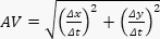 (3)
(3)
Dostęp ograniczony. Zaloguj się lub rozpocznij wersję próbną, aby wyświetlić tę treść.
Wyniki
Ilościowa analiza danych z okulografii wykazała znaczną różnicę w efektywności między głównymi kohortami, wskazując na obszary, w których współczesne projektowanie terminali może w niewystarczający sposób uwzględniać neuropoznawcze starzenie się organizmu. Analiza ilościowa ujawniła istotne różnice w efektywności nawigacji między dwiema kohortami. Grupa osób starszych z zaburzeniami widzenia wymagała znacznie więcej czasu na pokonanie sekwencji od kontroli bezpieczeństwa do bramki w porównaniu z młodszą grupą kontrolną z...
Dostęp ograniczony. Zaloguj się lub rozpocznij wersję próbną, aby wyświetlić tę treść.
Dyskusja
The transition from raw empirical data to actionable architectural intelligence requires rigorous deductive reasoning. To maintain scientific transparency, the following discussion explicitly delineates between direct behavioral observations measured in our eye-tracking and mixed-reality paradigms, and theoretical extrapolations based on established neurocognitive literature. The primary theoretical discovery of this research is the behavioral manifestation of the "Compensation Ceiling" effect. To understand the ...
Dostęp ograniczony. Zaloguj się lub rozpocznij wersję próbną, aby wyświetlić tę treść.
Oświadczenia
The authors have nothing to disclose.
Podziękowania
The authors would like to express their sincere gratitude for the support that made this study possible. This research was funded by the 7th Batch of the 2025 Ministry of Education of the PRC Industry-University Collaborative Education Program, specifically the Kingfar-CES Human Factors and Ergonomics Program under Program No. 20251109. Appreciation is also extended to the Xiamen Academy of Arts and Design at Fuzhou University and Xiamen Rekey Medical Technology Co., Ltd. for providing the collaborative environment necessary to conduct our neurocognitive and spatial navigation simulations.
Dostęp ograniczony. Zaloguj się lub rozpocznij wersję próbną, aby wyświetlić tę treść.
Materiały
| Nazwa | Firma | Numer katalogowy | Komentarze |
|---|---|---|---|
| Airport terminal wayfinding scenarios | Self-developed experimental setup | N/A (self-developed) | Standardized navigation task design for behavioral assessment |
| Microsoft HoloLens | Microsoft, USA | www.microsoft.com/hololens | Simulation of pathological visual impairment in mixed-reality conditions |
| OpenGL shaders | Custom programmed | www.opengl.org | Real-time rendering of simulated visual field defects |
| Tobii Pro Glasses 3 | Tobii Pro, Sweden | www.tobii.com/products/eye-trackers/wearables/tobii-pro-glasses-3 | Real-world eye-tracking data acquisition during wayfinding tasks |
| Tobii Pro Lab | Tobii Pro, Sweden | www.tobii.com/products/software/applications-and-tools/tobii-pro-lab | Recording and analysis of fixation, saccade, and gaze trajectory data |
Bibliografia
- Beard JR, et al. The World report on ageing and health: a policy framework for healthy ageing. Lancet. 2016;387(10033):2145–2154.
- Vollset SE, et al. Fertility, mortality, migration, and population scenarios for 195 countries and territories from 2017 to 2100: a forecasting analysis for the Global Burden of Disease Study. Lancet. 2020;396(10258):1285–1306.
- Swenor BK, Lee MJ, Tian J, Varadaraj V, Bandeen-Roche K. Visual impairment and frailty in older adults. JAMA Ophthalmol. 2020;138(1):11–19.
- Burton MJ, et al. The Lancet Global Health Commission on Global Eye Health: vision beyond 2020. Lancet Glob Health. 2021;9(4):e489–e551.
- Bourne RRA, et al. Causes of blindness and vision impairment in 2020 and trends over 30 years, and prevalence of avoidable blindness in relation to VISION 2020: the Right to Sight: an analysis for the Global Burden of Disease Study. Lancet Glob Health. 2021;9(2):e144–e160.
- Flaxman SR, et al. Global causes of blindness and distance vision impairment 1990-2020: a systematic review and meta-analysis. Lancet Glob Health. 2017;5(12):e1221–e1234.
- Wahl HW, Gerstorf D. Person-environment-behavior research: where we have been, where we are, and where we could be heading. Gerontologist. 2020;60(1):108–112.
- Chaudhury H, Oswald F. Advancing understanding of person-environment interaction in later life: a commentary. J Aging Stud. 2019;51:100808.
- Iwarsson S, Horstmann V, Carlsson G, Oswald F, Wahl HW. Importance of the home environment for healthy aging: a conceptual framework. Gerontologist. 2023;63(3):442–452.
- Jia G, Guo C, Han X, Zhu W, Ji M. Wayfinding behaviors of elderly passengers in airport terminals: an empirical study based on eye-tracking technology. Appl Ergon. 2022;106:103901.
- Chang YC, Chen CF. Meeting the needs of disabled air passengers: factors that facilitate help from airlines and airports. Tour Manage. 2017;63:161–171.
- Lester AW, Moffat SD, Wiener JM, Barnes CA, Wolbers T. The aging navigational system. Neuron. 2017;95(5):1019–1035.
- Rowland DC, Roudi Y, Moser MB, Moser EI. Ten years of grid cells. Annu Rev Neurosci. 2016;39:19–40.
- Stangl M, et al. Compromised grid-cell-like representations in old age as a key mechanism to explain age-related navigational deficits. Curr Biol. 2018;28(7):1108–1115.
- Zheng L, Gao Z, McAvan AS, Isham EA, Ekstrom AD. Hippocampal contributions to novel spatial learning are both age-related and age-invariant. Proc Natl Acad Sci U S A. 2024;121(3):e2307884120.
- Berron D, et al. Age-related functional changes in domain-specific pathways of the hippocampus. Proc Natl Acad Sci U S A. 2018;115(11):E2595–E2604.
- Koen JD, Rugg MD. Neural dedifferentiation in the aging brain. Trends Cogn Sci. 2019;23(7):547–559.
- Colombo D, et al. Egocentric and allocentric spatial reference frames in aging: a systematic review. Neurosci Biobehav Rev. 2017;80:605–621.
- Wang L, Wang X. Design mechanisms of airport visual guidance systems on passenger wayfinding performance: evidence from causal machine learning and a moderated mediation approach. J Air Transp Manage. 2024;115:102521.
- Churchill A, Dada E, de Barros AG, Wirasinghe SC. Quantifying and validating measures of airport terminal wayfinding. Journal of Air Transport Management. 2008;14(3):151–158.
- Jones PR, Somoskeöy T, Chow-Wing-Bom H, Crabb DP. Seeing other perspectives: evaluating the use of virtual and augmented reality to simulate visual impairments (OpenVisSim). npj Digital Medicine. 2020;3(1):32.
- Cabeza R, et al. Maintenance, reserve and compensation: the cognitive neuroscience of healthy ageing. Nat Rev Neurosci. 2018;19(11):701–710.
- Ringer RV, Throneburg Z, Johnson AP, Kramer AF, Loschky LC. Impairing the useful field of view in natural scenes: tunnel vision versus general interference. J Vis. 2016;16(2):1167.
- Legge GE, Chung STL. Low vision and reading: what makes a letter legible? Vision Res. 2016;129:117–130.
- Theeuwes J. Goal-driven, stimulus-driven, and history-driven selection. Curr Opin Psychol. 2019;29:97–101.
- Cowan N. The many faces of working memory and short-term storage. Psychon Bull Rev. 2017;24(4):1158–1170.
- Spiers HJ, Gilbert SJ. Solving the detour problem in navigation: a model of prefrontal and hippocampal interactions. Front Hum Neurosci. 2015;9:125.
- Rehman U, Cao S. Augmented-reality-based indoor navigation: a comparative analysis of handheld devices versus Google Glass. IEEE Trans Hum-Mach Syst. 2017;47(1):140–151.
Dostęp ograniczony. Zaloguj się lub rozpocznij wersję próbną, aby wyświetlić tę treść.